• Registration is easy and free!

  • Welcome to the National Parks USA forum! Registered members can download resources for free and use the forum without advertising banners. Click here for free registration. After registration, check your mailbox and confirm your email address.

Congaree National Park | Hiking, Kayaking & Travel Guide

Congaree National Park
National Park

Congaree National Park

South Carolina United States

Current park status

4 active alerts
Caution

Being Prepared for Excessive Heat & Humidity

Read more Show less
Congaree can be hot & humid from late spring through early fall. Be sure that you & your party (including pets) have adequate water & choose activities that fit your level of physical fitness. Consider visiting early in the morning when it is cooler.
Caution

Paddling Conditions

Read more Show less
Trees down across Cedar Creek between Bannister's Bridge and South Cedar Creek may require significant portages depending on water levels & paddlers should plan accordingly. All paddlers should have necessary equipment, including the 10 Essentials.
Caution

Backcountry Trail Conditions

Read more Show less
GPS is necessary on backcountry trails: Oakridge, Boggy Gut (formerly River), and Kingsnake. These trails may be difficult to follow.
Information

Planning Ahead for Transportation

Read more Show less
If being dropped off at the park, please ensure you will have a return ride. Taxis and rideshares do not often come out to Congaree, and the bus may be unavailable. Please plan ahead.

Stay Near This Park

Find a place to stay near Congaree National Park.

Compare hotels, cabins, campgrounds, RV parks and vacation rentals.

Search Accommodation
Accommodation search powered by Stay22.

Accommodation Map

Browse nearby accommodations around Congaree National Park.
National Park

Congaree National Park

Congaree National Park protects an extraordinary old-growth forest of towering hardwoods, wetlands, creeks, and floodplain landscapes near Columbia, South Carolina. Fed by the Congaree and Wateree Rivers, this remarkably intact bottomland forest contains some of the tallest trees in the eastern United States and offers a peaceful national park experience built around hiking, paddling, wildlife, and changing water levels.

The Boardwalk Loop Trail is the natural starting point for many first-time visitors. The elevated walkway leads through the floodplain forest, providing close views of enormous trees, wetlands, dwarf palmettos, and the complex ecosystem beneath the canopy. Interpretive stops along the route help explain how flooding shapes the landscape.

Hiking trails continue beyond the boardwalk into quieter sections of Congaree National Park. Depending on recent rainfall and river levels, trails may range from dry forest paths to muddy or flooded routes, making every visit slightly different.

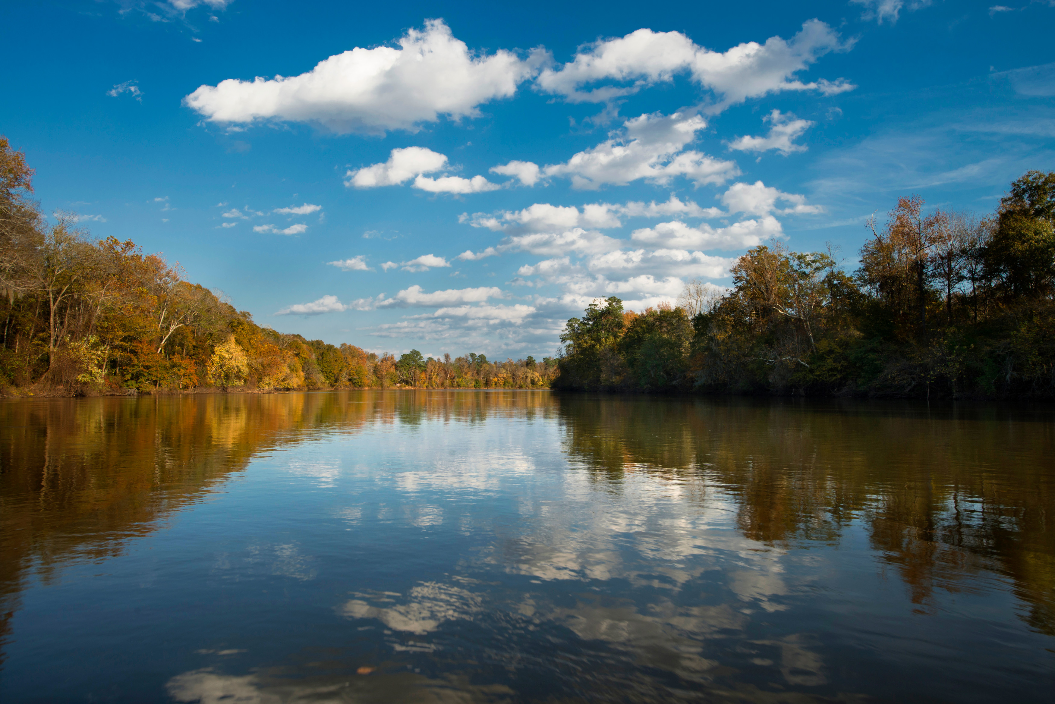
Cedar Creek provides one of the most memorable ways to experience the park. Canoes and kayaks can follow the marked Cedar Creek Canoe Trail beneath a canopy of old-growth trees. Paddling offers opportunities to observe turtles, birds, river otters, and other wildlife while exploring areas that feel far removed from nearby Columbia.

Birdwatching, fishing, photography, camping, ranger programs, and stargazing provide additional things to do. Congaree is also famous for synchronous fireflies, whose remarkable seasonal displays attract visitors when conditions are right.

There are no hotels, restaurants, or traditional lodging facilities inside Congaree National Park. Camping is available, while Columbia and surrounding South Carolina communities provide extensive hotels, restaurants, outfitters, and other visitor services.

Whether you walk the Boardwalk Loop, paddle Cedar Creek, explore backcountry trails, or visit to experience the forest after a seasonal flood, Congaree National Park reveals a side of the American Southeast that has disappeared from much of the surrounding region.

Things To Do

Explore Things To Do at Congaree National Park

Guided Experiences

Discover guided tours and memorable experiences near Congaree National Park.

Why book a guided experience?

Discover guided tours, tickets and activities available near Congaree National Park.
Flexible cancellation options
Instant confirmation
Convenient mobile tickets
Experienced local guides
Reviews from fellow travelers
Explore Guided Experiences
We may earn a commission when you book through this link.

Weather forecast

Plan your visit with the latest weather forecast for this park.
Tonight
56°F13°C
Mostly Clear
0 mph0 km/h
Tuesday
88°F31°C
Sunny
N 1 mph2 km/h
Tuesday Night
60°F16°C
Mostly Clear
NE 1 mph2 km/h
Wednesday
89°F32°C
Sunny
E 2 mph2 km/h Rain: 1%
Wednesday Night
63°F17°C
Mostly Clear
SE 2 mph2 km/h Rain: 1%
Thursday
90°F32°C
Sunny
E 2 mph2 km/h Rain: 2%
Forecast data provided by the National Weather Service.
Last updated: Sep 28, 2026 at 6:31 PM
Official forecast
Forecasts can change and local conditions may vary. Check official weather alerts and park guidance before your visit.

More weather details

Tonight
56°F13°C
Mostly Clear

Mostly clear, with a low around 56. Wind around 0 mph.

0 mph0 km/h
Tuesday
88°F31°C
Sunny

Sunny, with a high near 88. North wind around 1 mph.

N 1 mph2 km/h
Tuesday Night
60°F16°C
Mostly Clear

Mostly clear, with a low around 60. Northeast wind around 1 mph.

NE 1 mph2 km/h
Wednesday
89°F32°C
Sunny

Sunny, with a high near 89. East wind 0 to 3 mph.

E 2 mph2 km/h Rain: 1%
Wednesday Night
63°F17°C
Mostly Clear

Mostly clear, with a low around 63. Southeast wind 0 to 3 mph.

SE 2 mph2 km/h Rain: 1%
Thursday
90°F32°C
Sunny

Sunny, with a high near 90.

E 2 mph2 km/h Rain: 2%
Thursday Night
67°F19°C
Mostly Clear

Mostly clear, with a low around 67.

SE 2 mph2 km/h Rain: 2%
Friday
92°F33°C
Mostly Sunny then Slight Chance Rain Showers

A slight chance of rain showers after 2pm. Mostly sunny, with a high near 92.

S 2 mph3 km/h Rain: 16%
Friday Night
70°F21°C
Slight Chance Rain Showers

A slight chance of rain showers. Mostly cloudy, with a low around 70.

S 2 mph2 km/h Rain: 16%
Saturday
88°F31°C
Chance Rain Showers

A chance of rain showers before 2pm, then a chance of showers and thunderstorms. Partly sunny, with a high near 88. Chance of precipitation is 50%.

E 3 mph4 km/h Rain: 53%
Saturday Night
68°F20°C
Chance Showers And Thunderstorms

A chance of showers and thunderstorms. Mostly cloudy, with a low around 68. Chance of precipitation is 50%.

SE 3 mph5 km/h Rain: 53%
Sunday
84°F29°C
Chance Rain Showers

A chance of rain showers. Partly sunny, with a high near 84. Chance of precipitation is 50%.

SE 4 mph6 km/h Rain: 48%
Sunday Night
66°F19°C
Chance Rain Showers

A chance of rain showers. Mostly cloudy, with a low around 66. Chance of precipitation is 50%.

S 3 mph5 km/h Rain: 48%
Monday
78°F26°C
Chance Rain Showers

A chance of rain showers. Partly sunny, with a high near 78.

NE 5 mph8 km/h Rain: 45%

Disclaimer

Plan your visit with the latest weather forecast for this park.

Conditions can change quickly and may vary by elevation and location. Check the official forecast and park alerts before you travel.

Forecasts can change and local conditions may vary. Check official weather alerts and park guidance before your visit.

Location and map

View this park in your preferred navigation app for directions and nearby places.

Things To Buy

Recommended gear for Congaree National Park
We may earn a commission when you book through this link.

Directions

Congaree National Park is located approximately 20 miles southeast of Columbia, South Carolina. The Harry Hampton Visitor Center is the primary starting point for first-time visitors and provides access to the Boardwalk Loop Trail, hiking routes, campground information, and park exhibits. From Columbia, the most straightforward approach is to use Interstate 77 and Exit 5 toward South Carolina Highway 48, also known as Bluff Road. Continue southeast before following signs toward Old Bluff Road and the national park visitor center. Columbia Metropolitan Airport is the closest major commercial airport. Charleston and Charlotte are also within driving distance for travelers combining Congaree with a longer trip through the Carolinas. Use caution with GPS navigation when approaching the park. Some systems may suggest rural routes that include unpaved roads or less convenient approaches. Following the established route from Bluff Road and official park signs is generally easier. There is no public transportation within Congaree National Park, so a private or rental vehicle provides the greatest flexibility for reaching the visitor center and surrounding access points.

Climate

Congaree National Park has a humid subtropical climate with hot summers, mild winters, frequent rainfall, and periodic flooding that plays an essential role in the park’s floodplain ecosystem. Spring and fall generally provide the most comfortable conditions for hiking and paddling, with mild temperatures and lower humidity. However, rainfall and changing river levels can quickly affect trails and low-lying areas. Summer is hot and humid, with daytime temperatures frequently above 90°F and heat index values sometimes exceeding 100°F. Thunderstorms are common, and mosquitoes can become abundant during warm, wet conditions. Winter is generally mild compared with much of the United States, although freezing temperatures and occasional winter weather are possible. Flooding can occur at any time of year. Rain falling far upstream may raise the Congaree River and flood trails even when local weather is dry. Before visiting, check both the weather forecast and current river or trail conditions. Bring insect repellent, water, and appropriate footwear when exploring the floodplain.

Information & Disclaimer

National Parks Explorer strives to present accurate and up-to-date information collected from official and trusted sources, including the National Park Service. While we make every effort to keep this information current, information may be incomplete, inaccurate, outdated or subject to change without prior notice, including access requirements, permits, reservations, operating hours, alerts, fees, road and trail conditions, weather and other visitor information.


Read more Read less

Always verify the latest information with the relevant official source before making travel plans, reservations, purchases or visiting a park.

National Parks Explorer is an independent information platform provided through national-parks-usa.com and is not affiliated with or endorsed by the National Park Service or other data providers. All information is provided for general informational and planning purposes only and is used entirely at your own risk. To the fullest extent permitted by applicable law, National Parks Explorer and national-parks-usa.com cannot be held responsible or liable for any loss, damage, injury, inconvenience, missed reservation, travel disruption, financial loss, additional expense or other costs resulting from the use of, or reliance upon, information provided through this website.

Back
Top