• Registration is easy and free!

  • Welcome to the National Parks USA forum! Registered members can download resources for free and use the forum without advertising banners. Click here for free registration. After registration, check your mailbox and confirm your email address.

Hike in the South (Waterpocket) District - Capitol Reef National Park

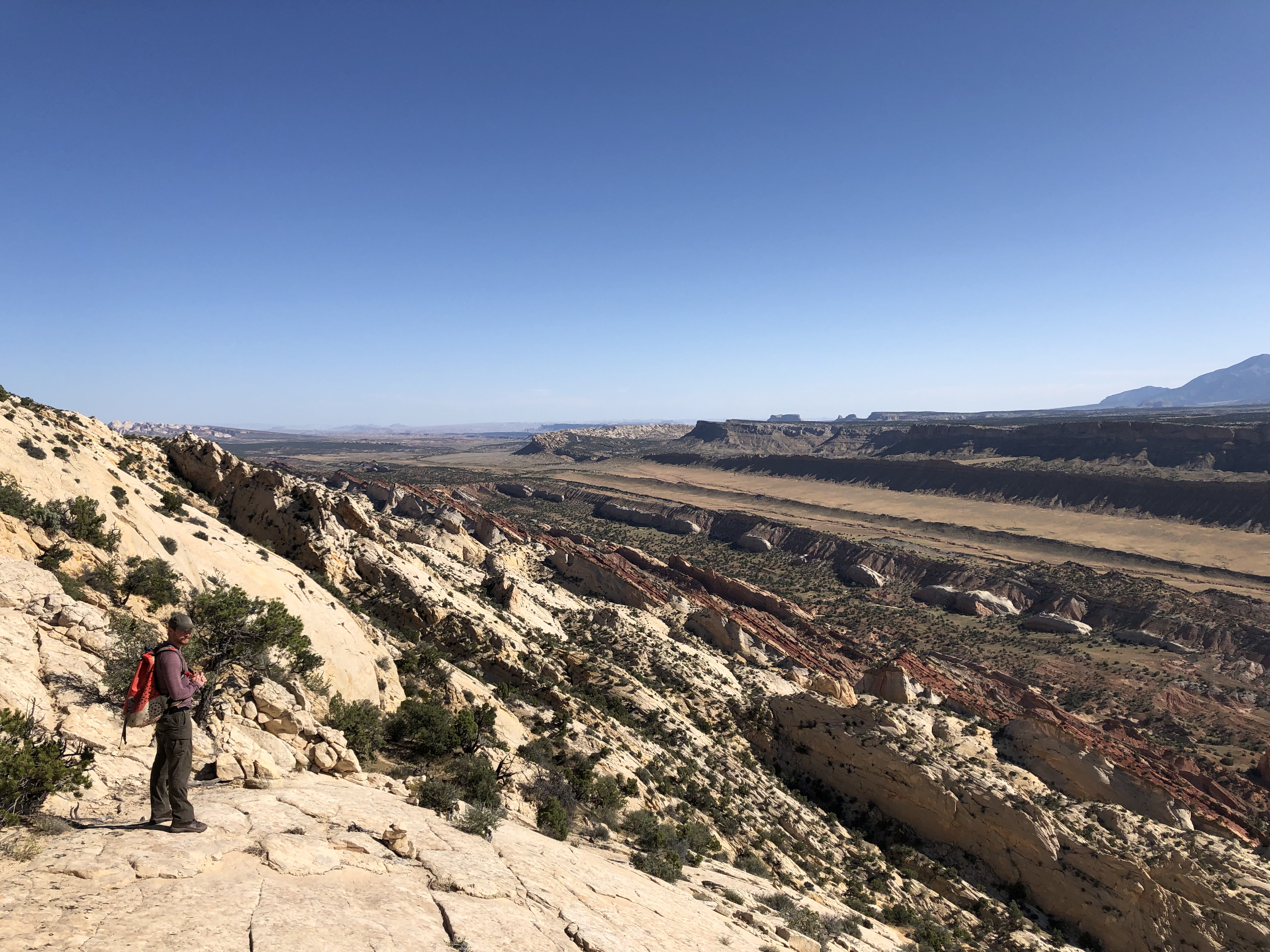
A hiker stands on top of rock cliff viewing vast valley below.
Backcountry Hiking

Hike in the South (Waterpocket) District

Capitol Reef National Park
Spring · Summer · Fall · Winter
Pets: No
Fees: Yes

Visitor Dashboard

Current park status

8 active alerts
Information

SR 24 Temporary Lane Closures

Read more Show less
UDOT will be repairing small sections of Utah Highway 24 through the park during August 2026. Expect one-lane closures with delays of up to 15 minutes.
Caution

Wildfire Smoke Impacts

Read more Show less
Smoke from nearby wildfires is impacting the park's air quality. Air quality is forecast to be in the unhealthy range for many areas in the park over the next 24 hours. Visitors should consider limiting exertion outdoors. Check Utah Fire Info for wildfire information and the following link for forecasts.
Caution

Monsoon Season & Flash Floods

Read more Show less
Heavy rains can cause sudden flooding, especially in canyons and washes. Do not drive or hike through flood waters. Get to high ground and wait for floods to subside. Some roads may close temporarily; closures are posted at the visitor center.
Information

Stage II Fire Restrictions

Read more Show less
Stage II fire restrictions are in effect until further notice. Campfires including charcoal are not permitted, even in established fire rings. Smoking is only permitted within an enclosed vehicle. Gas or liquid fueled portable camp stoves are still permitted.
Caution

Elevated E. Coli levels - Fremont River

Read more Show less
Recent water quality testing shows elevated E. coli levels in the Fremont River. Use caution if entering the water. Do not get water in your mouth, do not swim. Wash hands with soap and water.
Park Closure

Annual/Seasonal Canyoneering Closures

Read more Show less
The following are closed to entry through 8/31/2026 to protect sensitive resources: the heads of Fivemile Wash & Burro Wash descending east 2 miles; Shinob Canyon + all routes descending into Shinob (including Na-gah, Nighthawk, & Timpie); and Arch Nemesis Canyon, including the route exiting at Capitol Gorge + all direct tributary canyons.
Information

Reef Ride Bike Days 2026

Read more Show less
For this special event in honor of National Public Lands Day, the Scenic Drive will be closed to motor vehicles for part of the day on Saturday, September 19 and Saturday, September 26, 2026. The road will be closed to vehicles from sunrise to 3 pm to allow for bicycles and pedestrians to enjoy the road at a more leisurely pace. The main road through the park (UT highway 24) - will remain open and unaffected by this closure.
Information

Special Use Permits

Read more Show less
Special Use Permits are typically needed for activities that benefit a specific group. Examples include: Groups of 40 or more, trips organized by scouting groups, churches, or academic institutions, photography, weddings, and first amendment activities

About this activity

Get to know the South (Waterpocket) District on foot by hiking an easy trail or strenuous backcountry route. Many of these hikes are accessible only by unpaved roads.

Backcountry hiking opportunities abound in Capitol Reef's remote, southern Waterpocket District, ranging from one-hour walks to multi-day backpacking routes. Short-distance hikes into Red, Surprise, and Headquarters Canyons cut through multiple sedimentary rock layers, while slot canyons in Burro Wash, Cottonwood Wash, and Sheets Gulch are more arduous but rewarding. Upper and Lower Muley Twist Canyons and Halls Creek Narrows are popular overnight destinations. Use caution in narrow canyons, particularly during the flash flood season (typically July-September). Always check the weather forecast before your visit. Free backcountry permits are required for all overnight trips and can be obtained at the visitor center.

These routes are not official, maintained trails. Route conditions including obstacles in canyons, change frequently due to weather, flash floods, rockfall, and other hazards. Routefinding, navigation, and map-reading skills are critical. Do not rely solely on unofficial route markers (rock cairns, etc.); they are not maintained by the National Park Service (NPS), may not indicate the route in this description, or may be absent.A PDF version of this information can be downloaded and printed.


Easy and Moderate Trails

Red Canyon Trail and Route

5.6 miles (9.0 km) round trip
3-4 hours
Easy to moderate

Starting at Cedar Mesa Campground, the Red Canyon Trail bears southwest across a sagebrush flat before climbing a low ridge that affords views of the Henry Mountains to the east. Here the trail follows and old dugway northwest into Red Canyon. After 1.3 miles (2.0 km), the trail drops into a sandy wash flanked by cottonwood trees. Here the route simply follows the wash bottom for more than a mile into an amphitheater of high, Wingate sandstone walls. The hike ends at a fork in the gray-green and lavender clay of the Chinle formation, beyond which progress is obstructed by a collection of large boulders.

Surprise Canyon Route

2.0 miles (3.2 km) round trip
1-2 hours
Easy

The short Surprise Canyon route crosses a broad, grassy drainage before entering a deep canyon in the Waterpocket Fold. After crossing the dry wash bed of Halls Creek, bear slightly left to crest a small, grassy hill. From here the cairned trail meanders west among colorful outcrops before dropping steeply into a rocky ravine. From here, follow the wash bottom into the deep, relatively narrow canyon. The route ends at the base of a spiraling pouroff 1.0 mile (1.6 km) from the Burr Trail Road. A bypass on the left offers access to the canyon's upper reaches. However, progress is challenging due to large boulder jams and steep, crumbling slopes.

Headquarters Canyon Route

3.2 miles (5.2 km) round trip
2-3 hours
Easy

Headquarters Canyon features sheer, vertical walls and slopes of Navajo sandstone streaked with color. Departing from the Burr Trail Road, a signed, sandy track cuts west across a sagebrush flat and crosses the dry drainage of Halls Creek. Within 0.5 mile (0.4 km), the route crosses a couple of dry washes, edges, around orange Entrada sandstone outcrops, and descends to a wide, stony gulch. Follow this drainage west into the Waterpocket Fold. Less than one mile (1.6 km) from the start, the deep gorge constricts to a narrow slot usually free of significant obstacles. Beyond the slot, the canyon is flush with vegetation. The hike ends at a sandstone ramp in the ledge-forming Kayenta formation. A 6-foot (1.8 m) dryfall atop the slide is passable to agile climbers, but progress beyond is quickly halted by a much higher dryfall.

Strike Valley Overlook

0.9 mile (1.4 km) round trip
30 minutes-1 hour
Moderate

From the end of the 2.9-mile (4.7 km) Upper Muley Twist Road, it is a 0.4-mile (0.6 km) hike to Strike Valley Overlook. From the overlook high above the valley, nearly a dozen sedimentary rock layers representing nearly 150 million years of geologic history are on full display. The overlook, marked by a large rock cairn, sits atop a low saddle reached by way of a sandy trail, followed by two moderate-grade slickrock climbs. Driving the sandy and rock-strewn Strike Valley Overlook Road requires a high-clearance vehicle. Overnight camping is not permitted on the Strike Valley Overlook route.

Strenuous Backcountry Routes

Detailed information on these longer, strenuous routes is available separately.

Burro Wash/ Cottonwood Wash/ Sheets Gulch

Dayhikes into deep sandstone gorges and arduous slot canyon. Accessed from signed roadside parking areas along the Notom-Bullfrog Road.

Upper Muley Twist Canyon

Sandstone narrows, arches, and panoramic views from high slickrock ridges. Accessed from Upper Muley Twist Road via Burr Trail Road. Either a long dayhike or overnight trip. Either a long dayhike or overnight trip.

Lower Muley Twist Canyon

Long, sinuous canyon with narrows and large alcoves; scenic vistas and remote desert wilderness. Accessed either from Burr Trail Road or the Post Corral trailhead. Either a long dayhike or overnight trip, depending on the variation of the route chosen.

Halls Creek Narrows

Long, multi-day hike through dry desert landscapes, leading to a deep, narrow canyon at the park's remote southern tip. Involves wading or possible swimming through sections of narrows. Accessed from Halls Creek Overlook via Burr Trail Road. Check the Halls Creek weather forecast before your trip.

Rules and Regulations

  • Free permits are required for backcountry camping, and are available in-person at:
  • Dispersed/at-large camping is prohibited within the park, including at or near trailheads. Dispersed/at-large camping is allowed on federal lands (USFS, BLM) adjacent to the park.
  • Pets are not permitted on trails or in off-trail or backcountry areas. Pets are permitted on roads and in designated campgrounds.
  • Fires are prohibited, except within fire rings provided in designated campgrounds.
  • Collecting or damaging any park resource (plants, animals, wood, rocks, bones, antlers, artifacts, etc.) is prohibited.
  • Violation of these regulations may result in a citation.

Additional Information

Best Season:

Spring and fall.

Maps:

USGS 7.5-minute series: Golden Throne, Notom, Bear Canyon, Sandy Creek Benches, Bitter Creek Divide, Wagon Box Mesa, The Post, Deer Point, Stevens Canyon North, and Halls Mesa.

For more information:

Contact the Capitol Reef Visitor Center at 435-425-4111.


Activity details

Season
Spring, Summer, Fall, Winter
Time of day
Day, Night, Dawn, Dusk
Pets
No
Fees
Yes
Accessibility

Guided Experiences

Discover guided tours and memorable experiences near Capitol Reef National Park.

Why book a guided experience?

Discover guided tours, tickets and activities available near Capitol Reef National Park.

Flexible cancellation options
Instant confirmation
Convenient mobile tickets
Experienced local guides
Reviews from fellow travelers
Explore Guided Experiences
We may earn a commission when you book through this link.

Access requirement information

Not available

No additional access requirement details are available from the provider.

Official website

Official access information supplied by the provider for this activity. Requirements and availability may change, so always verify the latest details on the official website.
Visit official website

Weather forecast

Check the weather forecast before planning this activity.
This Afternoon
83°F28°C
Slight Chance Showers And Thunderstorms
SE 6 mph10 km/h Rain: 18%
Tonight
60°F16°C
Slight Chance Showers And Thunderstorms then Partly Cloudy
SW 5 mph8 km/h Rain: 13%
Sunday
85°F29°C
Mostly Sunny
E 4 mph6 km/h Rain: 6%
Sunday Night
62°F17°C
Partly Cloudy
SW 4 mph6 km/h Rain: 6%
Monday
88°F31°C
Sunny
SE 5 mph7 km/h
Monday Night
65°F18°C
Partly Cloudy
SSW 7 mph11 km/h
Forecast data provided by the National Weather Service.
Last updated: Aug 15, 2026 at 1:31 PM
Official forecast
Forecasts can change and local conditions may vary. Check official weather alerts and park guidance before your visit.

More weather details

This Afternoon
83°F28°C
Slight Chance Showers And Thunderstorms

A slight chance of showers and thunderstorms. Mostly sunny. High near 83, with temperatures falling to around 77 in the afternoon. Southeast wind around 6 mph. Chance of precipitation is 20%.

SE 6 mph10 km/h Rain: 18%
Tonight
60°F16°C
Slight Chance Showers And Thunderstorms then Partly Cloudy

A slight chance of showers and thunderstorms before 9pm. Partly cloudy. Low around 60, with temperatures rising to around 62 overnight. Southwest wind around 5 mph.

SW 5 mph8 km/h Rain: 13%
Sunday
85°F29°C
Mostly Sunny

Mostly sunny. High near 85, with temperatures falling to around 80 in the afternoon. East wind 2 to 6 mph.

E 4 mph6 km/h Rain: 6%
Sunday Night
62°F17°C
Partly Cloudy

Partly cloudy, with a low around 62. Southwest wind 2 to 6 mph.

SW 4 mph6 km/h Rain: 6%
Monday
88°F31°C
Sunny

Sunny, with a high near 88. Southeast wind 0 to 9 mph.

SE 5 mph7 km/h
Monday Night
65°F18°C
Partly Cloudy

Partly cloudy, with a low around 65.

SSW 7 mph11 km/h
Tuesday
90°F32°C
Mostly Sunny

Mostly sunny, with a high near 90.

SW 6 mph9 km/h Rain: 5%
Tuesday Night
66°F19°C
Mostly Cloudy

Mostly cloudy, with a low around 66.

WSW 7 mph10 km/h Rain: 2%
Wednesday
91°F33°C
Mostly Sunny

Mostly sunny, with a high near 91.

SSW 5 mph8 km/h Rain: 6%
Wednesday Night
67°F19°C
Partly Cloudy

Partly cloudy, with a low around 67.

WSW 6 mph10 km/h Rain: 6%
Thursday
91°F33°C
Mostly Sunny then Slight Chance Showers And Thunderstorms

A slight chance of showers and thunderstorms after noon. Mostly sunny, with a high near 91.

SW 4 mph6 km/h Rain: 15%
Thursday Night
68°F20°C
Slight Chance Showers And Thunderstorms then Partly Cloudy

A slight chance of showers and thunderstorms before midnight. Partly cloudy, with a low around 68.

SW 6 mph10 km/h Rain: 11%
Friday
91°F33°C
Mostly Sunny then Chance Showers And Thunderstorms

A chance of showers and thunderstorms after noon. Mostly sunny, with a high near 91.

S 5 mph7 km/h Rain: 25%
Friday Night
67°F19°C
Slight Chance Showers And Thunderstorms then Partly Cloudy

A slight chance of showers and thunderstorms before midnight. Partly cloudy, with a low around 67.

WSW 4 mph6 km/h Rain: 22%

Disclaimer

Check the weather forecast before planning this activity.

Weather, wind, precipitation and temperature can vary by location and time. Prepare appropriate clothing and equipment and check official alerts and park guidance.

Forecasts can change and local conditions may vary. Check official weather alerts and park guidance before your visit.

Location and map

View this park in your preferred navigation app for directions and nearby places.

More Things To Do at Capitol Reef National Park

Explore Things To Do at Capitol Reef National Park

Information & Disclaimer

National Parks Explorer strives to present accurate and up-to-date information collected from official and trusted sources, including the National Park Service. While we make every effort to keep this information current, information may be incomplete, inaccurate, outdated or subject to change without prior notice, including access requirements, permits, reservations, operating hours, alerts, fees, road and trail conditions, weather and other visitor information.
Read more Read less

Always verify the latest information with the relevant official source before making travel plans, reservations, purchases or visiting a park.

National Parks Explorer is an independent information platform provided through national-parks-usa.com and is not affiliated with or endorsed by the National Park Service or other data providers. All information is provided for general informational and planning purposes only and is used entirely at your own risk. To the fullest extent permitted by applicable law, National Parks Explorer and national-parks-usa.com cannot be held responsible or liable for any loss, damage, injury, inconvenience, missed reservation, travel disruption, financial loss, additional expense or other costs resulting from the use of, or reliance upon, information provided through this website.

Back
Top