• Registration is easy and free!

  • Welcome to the National Parks USA forum! Registered members can download resources for free and use the forum without advertising banners. Click here for free registration. After registration, check your mailbox and confirm your email address.

Rock Climbing in Yosemite - Yosemite National Park

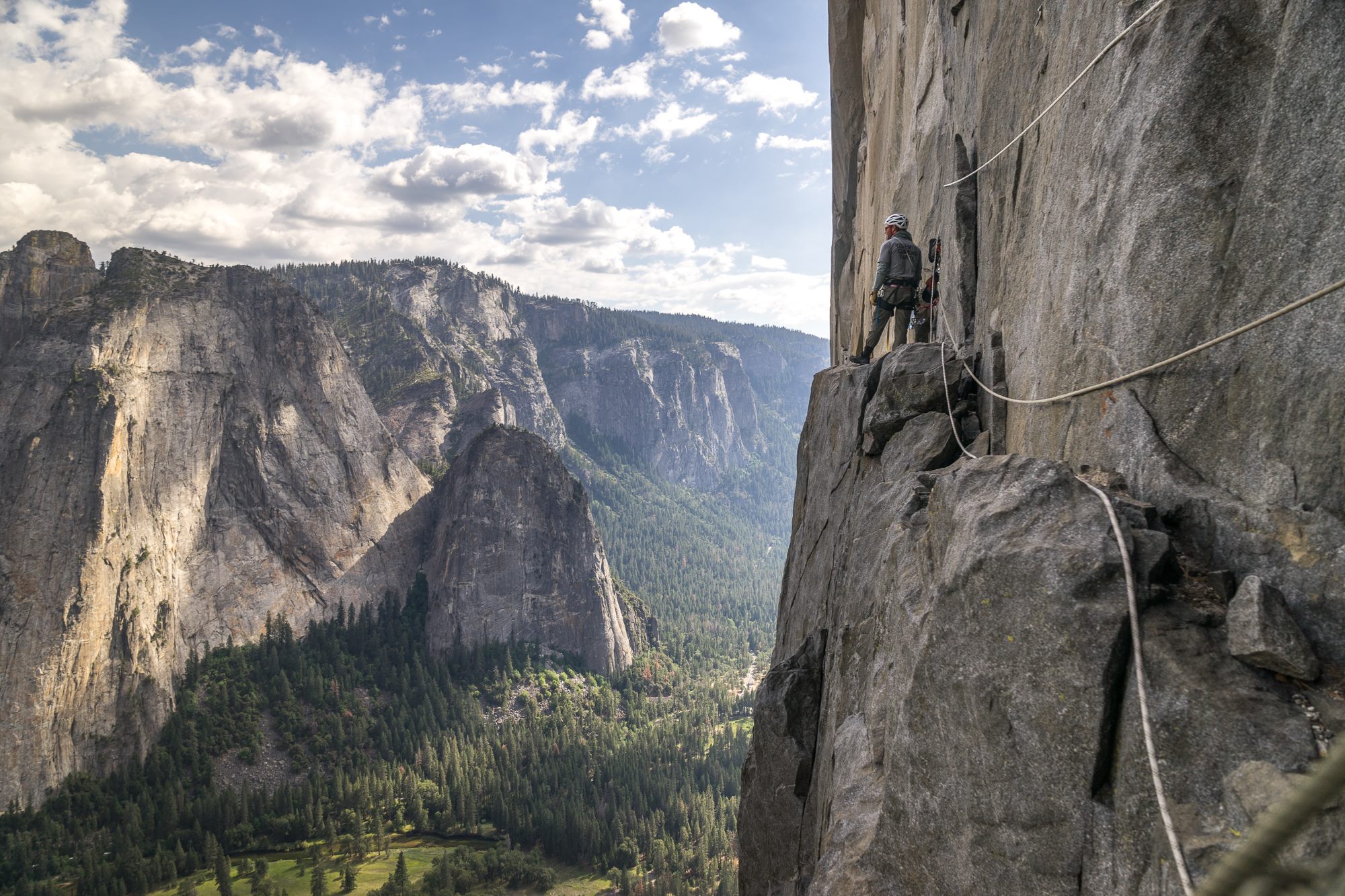
Climber on ledge on rock face with ropes in Yosemite Valley
Rock Climbing

Rock Climbing in Yosemite

Yosemite National Park
Pets: No
Fees: No

Visitor Dashboard

Current park status

7 active alerts
Park Closure

Tioga Road and Glacier Point Road are temporarily closed

Read more Show less
Tioga Road (continuation of Highway 120 through the park) and Glacier Point Road are temporarily closed due to a forecast of snow. Call 209/372-0200 (then 1, 1) to check road conditions in the park.
Park Closure

Tioga Road is temporarily closed due to snowy and icy conditions

Read more Show less
Tioga Road (continuation of Highway 120 through the park) is temporarily closed due to snowy and icy conditions. Call 209/372-0200 (then 1, 1) to check road conditions in the park.
Park Closure

Tioga Road and Glacier Point Road are temporarily closed due to snow

Read more Show less
Tioga Road (continuation of Highway 120 through the park) and Glacier Point Road temporarily closed due to snow. Call 209/372-0200 (then 1, 1) to check road conditions in the park.
Information

No overnight parking on Tioga & Glacier Point Roads

Read more Show less
Overnight parking is not allowed on Tioga Road and Glacier Point Road, including all parking lots reachable from these roads.
Park Closure

Glacier Point Road is closed due to the Dome Fire until 10/10 at 7 am

Read more Show less
The Dome Fire is burning in the wilderness northeast of Wawona. Glacier Point Road is closed until Saturday, October 10, at 7 am because of reduced visibility along the road due to smoke and to safely allow firefighting operations. Additionally, there are some trail closures south of Glacier Point Road.. Smoky conditions are possible at times.
Information

Dome Fire causing minimal impacts

Read more Show less
The Dome Fire is burning in the wilderness northeast of Wawona, resulting in a few trail closures. Smoky conditions are possible.
Information

Yosemite Traffic Updates

Read more Show less
When the park is very busy, you can get updates on current traffic conditions in Yosemite by texting ynptraffic to 333111.

About this activity

Yosemite is one of the world's greatest climbing areas. Climbers here can enjoy an endless variety of challenges--from the sustained crack climbs of the Merced River Canyon to pinching crystals on sun-drenched Tuolumne Meadows domes to multi-day aid climbs on the big walls of the Valley. Yosemite is not just a climber's playground, however: its walls and crags are an integral part of a larger ecosystem, protected as Wilderness.

Yosemite is one of the world's greatest climbing areas. Climbers here can enjoy an endless variety of challenges--from the sustained crack climbs of the Merced River Canyon to pinching crystals on sun-drenched Tuolumne Meadows domes to multi-day aid climbs on the big walls of the Valley. Yosemite is not just a climber's playground, however: its walls and crags are an integral part of a larger ecosystem, protected as Wilderness, which was set aside for people to enjoy in a natural state for generations to come.

Climbing in Yosemite has inherent risks and climbers assume complete responsibility for their own safety. The National Park Service does not maintain routes; loose rock and other hazards can exist on any route. Rescue is not a certainty. If you get into difficulties, be prepared to get yourself out of them. Know what to do in any emergency, including injuries, evacuations, unplanned bivouacs, or rapid changes in weather. Safety depends on having the right gear and the right attitude. Practice self-rescue techniques before you need them! Courtesy is an element of safety. Falling rock or gear is a serious hazard. Be careful when climbing above others. Do not create a dangerous situation by passing another party without their consent.

  • Do not litter, toss, or cache anything. If you hauled it up, you can carry it down.

  • If you must have a fire, use an existing fire ring.

  • Do not build windbreaks, platforms, or other "improvements."

Half Dome: Camping at the base of Half Dome is legal, but a wilderness permit is required. Camping on the summit of Half Dome is prohibited.

For climbing instruction, contact Yosemite Mountaineering School and Guide Service at 209/372-1000 for information on rates and schedules.

Activity details

Pets
No
Fees
No
Accessibility

Guided Experiences

Discover guided tours and memorable experiences near Yosemite National Park.

Why book a guided experience?

Discover guided tours, tickets and activities available near Yosemite National Park.

Flexible cancellation options
Instant confirmation
Convenient mobile tickets
Experienced local guides
Reviews from fellow travelers
Explore Guided Experiences
We may earn a commission when you book through this link.

Access requirement information

Not available

No additional access requirement details are available from the provider.

Official website

Official access information supplied by the provider for this activity. Requirements and availability may change, so always verify the latest details on the official website.
Visit official website

Weather forecast

Check the weather forecast before planning this activity.
Weather alerts active
Winter Storm Watch
Tonight
27°F-3°C
Mostly Cloudy then Chance Light Snow
S 8 mph12 km/h Rain: 45%
Monday
32°F0°C
Light Snow
SW 3 mph4 km/h Rain: 94%
Monday Night
12°F-11°C
Light Snow
WNW 3 mph4 km/h Rain: 87%
Tuesday
25°F-4°C
Sunny
S 3 mph4 km/h Rain: 6%
Tuesday Night
13°F-11°C
Partly Cloudy then Light Snow Likely
SSE 5 mph8 km/h Rain: 62%
Wednesday
26°F-3°C
Heavy Snow
S 8 mph12 km/h Rain: 99%
Forecast data provided by the National Weather Service.
Last updated: Nov 15, 2026 at 8:13 PM
Official forecast
Forecasts can change and local conditions may vary. Check official weather alerts and park guidance before your visit.

More weather details

Tonight
27°F-3°C
Mostly Cloudy then Chance Light Snow

A chance of snow after 4am. Mostly cloudy. Low around 27, with temperatures rising to around 29 overnight. Wind chill values as low as 21. South wind 5 to 10 mph, with gusts as high as 20 mph. Chance of precipitation is 50%. New snow accumulation of less than one inch possible.

S 8 mph12 km/h Rain: 45%
Monday
32°F0°C
Light Snow

Snow. Cloudy. High near 32, with temperatures falling to around 26 in the afternoon. Wind chill values as low as 21. Southwest wind 0 to 5 mph. Chance of precipitation is 90%. New snow accumulation of 4 to 8 inches possible.

SW 3 mph4 km/h Rain: 94%
Monday Night
12°F-11°C
Light Snow

Snow before 4am. Mostly cloudy. Low around 12, with temperatures rising to around 14 overnight. Wind chill values as low as 14. West northwest wind 0 to 5 mph. Chance of precipitation is 90%. New snow accumulation of 2 to 4 inches possible.

WNW 3 mph4 km/h Rain: 87%
Tuesday
25°F-4°C
Sunny

Sunny, with a high near 25. Wind chill values as low as 6. South wind 0 to 5 mph.

S 3 mph4 km/h Rain: 6%
Tuesday Night
13°F-11°C
Partly Cloudy then Light Snow Likely

Snow likely after 4am. Partly cloudy, with a low around 13. South southeast wind 0 to 10 mph, with gusts as high as 20 mph. Chance of precipitation is 60%. New snow accumulation of 1 to 2 inches possible.

SSE 5 mph8 km/h Rain: 62%
Wednesday
26°F-3°C
Heavy Snow

Snow before 4pm, then snow showers and a slight chance of thunderstorms. Cloudy, with a high near 26. South wind 5 to 10 mph, with gusts as high as 30 mph. Chance of precipitation is 100%. New snow accumulation of 15 to 21 inches possible.

S 8 mph12 km/h Rain: 99%
Wednesday Night
21°F-6°C
Snow Showers

Snow showers and a slight chance of thunderstorms before 4am, then snow. Cloudy, with a low around 21. South southwest wind 10 to 20 mph, with gusts as high as 40 mph. Chance of precipitation is 100%. New snow accumulation of 20 to 26 inches possible.

SSW 15 mph24 km/h Rain: 99%
Thursday
24°F-4°C
Snow then Snow Showers

Snow before 10am, then snow showers and a slight chance of thunderstorms. Cloudy, with a high near 24. South southwest wind 5 to 15 mph, with gusts as high as 35 mph. Chance of precipitation is 100%. New snow accumulation of 12 to 18 inches possible.

SSW 10 mph16 km/h Rain: 97%
Thursday Night
15°F-9°C
Snow Showers then Snow Likely

Snow showers and a slight chance of thunderstorms before 10pm, then snow likely. Mostly cloudy, with a low around 15. South southwest wind 5 to 10 mph, with gusts as high as 20 mph. Chance of precipitation is 90%. New snow accumulation of 7 to 11 inches possible.

SSW 8 mph12 km/h Rain: 88%
Friday
25°F-4°C
Chance Light Snow

A chance of snow before 4pm. Mostly sunny, with a high near 25. West southwest wind 0 to 5 mph. Chance of precipitation is 50%. New snow accumulation of 1 to 2 inches possible.

WSW 3 mph4 km/h Rain: 45%
Friday Night
11°F-12°C
Partly Cloudy

Partly cloudy, with a low around 11. East southeast wind 0 to 5 mph.

ESE 3 mph4 km/h Rain: 6%
Saturday
31°F-1°C
Mostly Sunny then Chance Light Snow

A chance of snow after 4pm. Mostly sunny, with a high near 31. South southwest wind 0 to 5 mph. Chance of precipitation is 30%. New snow accumulation of less than half an inch possible.

SSW 3 mph4 km/h Rain: 27%
Saturday Night
17°F-8°C
Chance Light Snow

A chance of snow. Mostly cloudy, with a low around 17. Southeast wind 0 to 5 mph. Chance of precipitation is 30%. New snow accumulation of around one inch possible.

SE 3 mph4 km/h Rain: 34%
Sunday
31°F-1°C
Chance Light Snow

A chance of snow before 5pm. Partly sunny, with a high near 31. South southeast wind 0 to 5 mph. Chance of precipitation is 40%. New snow accumulation of less than one inch possible.

SSE 3 mph4 km/h Rain: 36%

Weather alerts

Winter Storm Watch

Winter Storm Watch issued November 15 at 11:19AM PST until November 20 at 4:00AM PST by NWS Hanford CA

* WHAT...For the Winter Weather Advisory, snow accumulations up to 6 inches. For the Winter Storm Watch Above 5, 000 feet, heavy snow possible. Total snow accumulations between 1 to 2 feet expected above this elevation; accumulations around 4 feet above 8,000 feet. Winds could gust as high as 45 mph. * WHERE...Sierra Nevada above 5,000 feet. * WHEN...For the Winter Weather Advisory, until 4 AM PST Tuesday. For the Winter Storm Watch, from late Tuesday night through late Thursday night. * IMPACTS...Travel could be very difficult to impossible. The hazardous conditions will impact daily travel. Gusty winds could bring down tree branches. Roads, and especially bridges and overpasses, will likely become slick and hazardous.

Monitor the latest forecasts for updates on this situation. Persons are urged to stay indoors until conditions improve. If you must go outside, dress in layers. Several layers of clothes will keep you warmer than a single heavy coat. Cover exposed skin to reduce your risk of frostbite or hypothermia. Gloves, a scarf, and a hat will keep you from losing your body heat. Persons should consider delaying all travel. If travel is absolutely necessary, drive with extreme caution. Consider taking a winter storm kit along with you, including such items as tire chains, booster cables, flashlight, shovel, blankets and extra clothing. Also take water, a first aid kit, and anything else that would help you survive in case you become stranded. Slow down and use caution while traveling. The latest road conditions for the state you are calling from can be obtained by calling 5 1 1.

Winter Weather Advisory

Winter Weather Advisory issued November 15 at 11:19AM PST until November 17 at 4:00AM PST by NWS Hanford CA

* WHAT...For the Winter Weather Advisory, snow accumulations up to 6 inches. For the Winter Storm Watch Above 5, 000 feet, heavy snow possible. Total snow accumulations between 1 to 2 feet expected above this elevation; accumulations around 4 feet above 8,000 feet. Winds could gust as high as 45 mph. * WHERE...Sierra Nevada above 5,000 feet. * WHEN...For the Winter Weather Advisory, until 4 AM PST Tuesday. For the Winter Storm Watch, from late Tuesday night through late Thursday night. * IMPACTS...Travel could be very difficult to impossible. The hazardous conditions will impact daily travel. Gusty winds could bring down tree branches. Roads, and especially bridges and overpasses, will likely become slick and hazardous.

Monitor the latest forecasts for updates on this situation. Persons are urged to stay indoors until conditions improve. If you must go outside, dress in layers. Several layers of clothes will keep you warmer than a single heavy coat. Cover exposed skin to reduce your risk of frostbite or hypothermia. Gloves, a scarf, and a hat will keep you from losing your body heat. Persons should consider delaying all travel. If travel is absolutely necessary, drive with extreme caution. Consider taking a winter storm kit along with you, including such items as tire chains, booster cables, flashlight, shovel, blankets and extra clothing. Also take water, a first aid kit, and anything else that would help you survive in case you become stranded. Slow down and use caution while traveling. The latest road conditions for the state you are calling from can be obtained by calling 5 1 1.

Disclaimer

Check the weather forecast before planning this activity.

Weather, wind, precipitation and temperature can vary by location and time. Prepare appropriate clothing and equipment and check official alerts and park guidance.

Forecasts can change and local conditions may vary. Check official weather alerts and park guidance before your visit.

Location and map

View this park in your preferred navigation app for directions and nearby places.

More Things To Do at Yosemite National Park

Explore Things To Do at Yosemite National Park

Information & Disclaimer

National Parks Explorer strives to present accurate and up-to-date information collected from official and trusted sources, including the National Park Service. While we make every effort to keep this information current, information may be incomplete, inaccurate, outdated or subject to change without prior notice, including access requirements, permits, reservations, operating hours, alerts, fees, road and trail conditions, weather and other visitor information.

Read more Read less

Always verify the latest information with the relevant official source before making travel plans, reservations, purchases or visiting a park.

National Parks Explorer is an independent information platform provided through national-parks-usa.com and is not affiliated with or endorsed by the National Park Service or other data providers. All information is provided for general informational and planning purposes only and is used entirely at your own risk. To the fullest extent permitted by applicable law, National Parks Explorer and national-parks-usa.com cannot be held responsible or liable for any loss, damage, injury, inconvenience, missed reservation, travel disruption, financial loss, additional expense or other costs resulting from the use of, or reliance upon, information provided through this website.

Back
Top